Manuscripts, Books, and Maps: The Printing Press and a Changing World
Maps
The final aspect of print and its effects on European life has more to
do with economics than it does with culture: print maps and
geographical information for European expansion into the new world.
Early maps of the world were religious icons, just like those icons on
the carpet page of the Book of Kells.
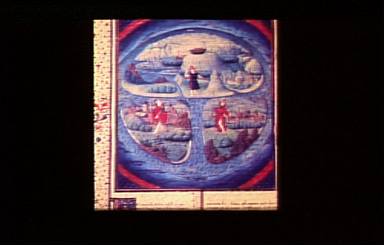
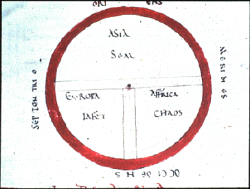
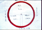 This 12th Century map of the world is called a "T and O" map because of
the shape of the image. The world it portrays is a circle, divided by
a T-shaped cross, the center of which is in Jerusalem. The circle
represents perfection - the world as the object of God's affection.
The world is is divided into three continents, named after the sons of
Noah. This map represented the Church's truth. It conveyed everything
important to know for those who lived in a world where nature was
unfolding according to God's plan.
This 12th Century map of the world is called a "T and O" map because of
the shape of the image. The world it portrays is a circle, divided by
a T-shaped cross, the center of which is in Jerusalem. The circle
represents perfection - the world as the object of God's affection.
The world is is divided into three continents, named after the sons of
Noah. This map represented the Church's truth. It conveyed everything
important to know for those who lived in a world where nature was
unfolding according to God's plan.
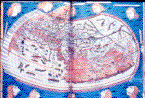
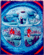 As maps, these may have represented the veneration of God, but neither
was useful as a tool for travel. Even though this second image is from
the 15th century, it retains the same, iconic and religious qualities
of the early manuscript books - the world is still three continents,
named for the sons of Noah. While the later version of the "T and O"
map shows a more naturalistic view - the continents are represented by
representations of real people - there is still no sense of
perspective in the image.
As maps, these may have represented the veneration of God, but neither
was useful as a tool for travel. Even though this second image is from
the 15th century, it retains the same, iconic and religious qualities
of the early manuscript books - the world is still three continents,
named for the sons of Noah. While the later version of the "T and O"
map shows a more naturalistic view - the continents are represented by
representations of real people - there is still no sense of
perspective in the image.
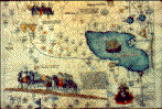
And, the ideological content of the map remains the same as the 12th
century version, with a view of the Ark at the top of the map.
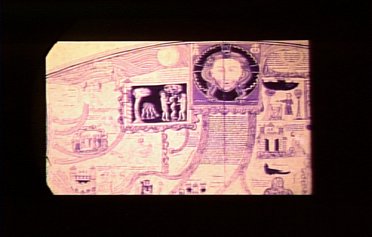
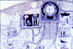 Along side of the development of manuscript books with a focus on the
outside, secular world, maps begin to evince similar concerns.
Although this map predates the last the 15th century map, it shows a
rising secular concern in its representation of the world. For
instance, it shows India, just below the Garden of Eden. It also has
real rivers and real, named places, in geographical relations to each
other, all existing along side the religious icons.
Along side of the development of manuscript books with a focus on the
outside, secular world, maps begin to evince similar concerns.
Although this map predates the last the 15th century map, it shows a
rising secular concern in its representation of the world. For
instance, it shows India, just below the Garden of Eden. It also has
real rivers and real, named places, in geographical relations to each
other, all existing along side the religious icons.
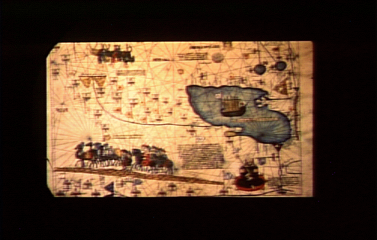
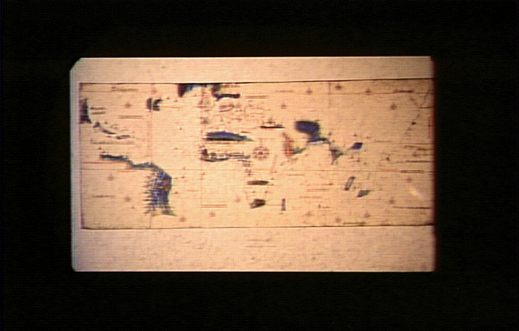
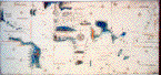
 The information on early manuscript maps that try to represent the
world is drawn from traveler's reports of their journeys.
Representations of Europe tend to be accurate but outside Europe, where
the world was less well-known, the map gets less accurate. In the case
of this image, from the
Catalan Atlas
of 1375, Europe is fairly well laid out, while China and the East,
known primarily at the time from the travels of Marco Polo (whom this
map shows), is less well defined.
The information on early manuscript maps that try to represent the
world is drawn from traveler's reports of their journeys.
Representations of Europe tend to be accurate but outside Europe, where
the world was less well-known, the map gets less accurate. In the case
of this image, from the
Catalan Atlas
of 1375, Europe is fairly well laid out, while China and the East,
known primarily at the time from the travels of Marco Polo (whom this
map shows), is less well defined.
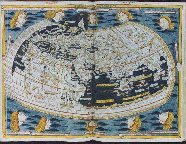
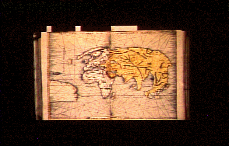
 Here is a later map, by
Ptolemy.
The impulse in this kind of map making is toward an accurate
representation of the world, an impulse toward creating information
that can be used to navigate in the world.
Here is a later map, by
Ptolemy.
The impulse in this kind of map making is toward an accurate
representation of the world, an impulse toward creating information
that can be used to navigate in the world.
Ptolemy's map was represented the state of understanding of the
world until Columbus's journey in 1492.
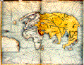
As mentioned above, the earliest secular texts to be printed were the
works of Greek and Roman antiquity. This is a "modern" reproduction of
a map of Ptolemy, a 2nd century geographer and astronomer. The
reproduction of this map was part of an emerging humanist tradition, an
attempt to reproduce classical manuscripts, not to spread useful
information. On this map, Africa is represented as part of the
"Southern Continent". This was inconsistent with the state of
geographic knowledge at this time. Far more was known about the west
coast of Africa because Henry of Portugal (Henry the Navigator) had
begun sending ships down the coast of Africa in the early 15th
century. This was not intended to be an instrument for navigation.
 Other manuscript maps contained real geographical information, albeit
not necessarily to geophysical scale. On this map, India, the Cantino
World Map created in about 1502, the center of the spice trade, is
enlarged in proportion to its economic importance to the world at the
time.
Other manuscript maps contained real geographical information, albeit
not necessarily to geophysical scale. On this map, India, the Cantino
World Map created in about 1502, the center of the spice trade, is
enlarged in proportion to its economic importance to the world at the
time.
 These maps show another kind of distortion as well. In the early
1500s, the Pope divided the known world into Spanish territory and
Portuguese territory. Depending on the politics of the map makers,
different areas of the world might be shifted one way or another,
placing them in either Spanish or Portuguese territory.
These maps show another kind of distortion as well. In the early
1500s, the Pope divided the known world into Spanish territory and
Portuguese territory. Depending on the politics of the map makers,
different areas of the world might be shifted one way or another,
placing them in either Spanish or Portuguese territory.
In the early years of the exploration of the New Worlds, all geographic
information was collected by Portuguese and Spanish explorers. The
information the gathered was tightly controlled by their governments
because control of accurate geographical information meant control of
important political and economic resources - control of the world.
By controlling this information, the Iberians managed to keep the
British and the French out of the expansion of the early 16th century
because they didn't have the necessary information.
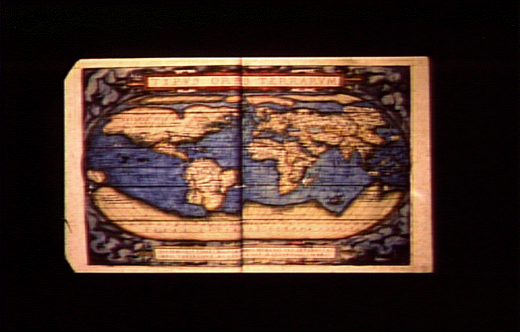
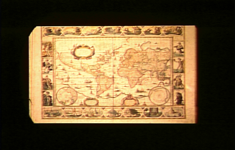
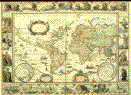
 When the Dutch managed to pull away from Spanish control, they became a
center for the reproduction of geographical information. They learned
cartography under the Spaniards, and had collected that information in
Holland. This is a world map printed in 1570 by
Abraham Ortelius
, 1527-1598, entitled,
Theatrum Orbis Terrarum.
When the Dutch managed to pull away from Spanish control, they became a
center for the reproduction of geographical information. They learned
cartography under the Spaniards, and had collected that information in
Holland. This is a world map printed in 1570 by
Abraham Ortelius
, 1527-1598, entitled,
Theatrum Orbis Terrarum.
Once freed from Spanish control, the publication of maps engendered the
same kind of comparison between texts (maps) as that for scientific
texts. Once the Dutch provided these maps to the British and French,
their further exploration of the world produced more information
against which current maps could be compared and updated, ruining
Iberian control of the New World territories.
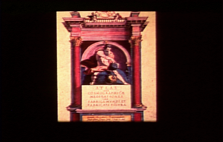
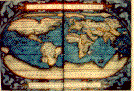
 This exploration and exchange and comparison of information - both in
maps and in printed books - changed Europe's view of the world. The
world was once a place once largely unknown - represented by the Greek
mythological image of Atlas carrying a huge globe on his shoulders Now,
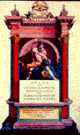
in the most famous atlas of the period,
Mercator's Atlas
of 1595, Atlas plays with the earth like a basketball. The globe has
become manageable, controllable, a resource to be exploited, no longer
the realm of the unknown.
This exploration and exchange and comparison of information - both in
maps and in printed books - changed Europe's view of the world. The
world was once a place once largely unknown - represented by the Greek
mythological image of Atlas carrying a huge globe on his shoulders Now,
in the most famous atlas of the period,
Mercator's Atlas
of 1595, Atlas plays with the earth like a basketball. The globe has
become manageable, controllable, a resource to be exploited, no longer
the realm of the unknown.
 Modern maps, showing the world in ways that allowed a reader to leave
home and return, also allowed for European expansion into the new
world, and the creation of a European-centered world economy.
Modern maps, showing the world in ways that allowed a reader to leave
home and return, also allowed for European expansion into the new
world, and the creation of a European-centered world economy.
The new world economy was characterized by a system of nation states in
economic competition with each other. The critical aspect of the
period was that no one of these states was strong enough to dominate
the others. Together, these states produced a world economy. However,
unlike earlier empires like the Hapsburg empire, where the fate of the
economy was dependent on the stability of the empire, in this new world
system, the economic system would continue when a state or government
died. It no longer mattered which states were involved in that
competition, the economic activity would be sustained because there was
no one dominant political group.
What arose was an economic system of unparalleled stability that lasted
well into the Industrial Revolution and beyond - Hudson's Bay Company is
still in business in Canada and there are probably still vestiges of
the East India Company, founders of the British Empire, in corners of
the globe.
Goto the next chapter
Return to the Books Table of Contents
This page last updated on:
Jan 30 1997
 This 12th Century map of the world is called a "T and O" map because of
the shape of the image. The world it portrays is a circle, divided by
a T-shaped cross, the center of which is in Jerusalem. The circle
represents perfection - the world as the object of God's affection.
The world is is divided into three continents, named after the sons of
Noah. This map represented the Church's truth. It conveyed everything
important to know for those who lived in a world where nature was
unfolding according to God's plan.
This 12th Century map of the world is called a "T and O" map because of
the shape of the image. The world it portrays is a circle, divided by
a T-shaped cross, the center of which is in Jerusalem. The circle
represents perfection - the world as the object of God's affection.
The world is is divided into three continents, named after the sons of
Noah. This map represented the Church's truth. It conveyed everything
important to know for those who lived in a world where nature was
unfolding according to God's plan.